| Camp Hero/Montauk Air Force Station |

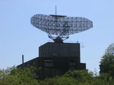
| Camp Hero (AKA Fort Hero or the Montauk Air Force Base) was a military base at Montauk Point on the eastern tip of Long Island, New York. It was decommissioned in the 1980's and is now owned by The New York State Department of Parks as Camp Hero State Park. The park offers a beach, fishing, hiking, a bridle path, biking, and cross-country skiing. Early History The eastern tip of Long Island has always had strategic significance, even in the days of the American Revolution. When the Montauk Lighthouse was first authorized in 1792, part of its mission was to keep a lookout for British ships sailing for New York or Boston, and as such was the first military installation at Montauk. WWI Montauk itself, with its remoteness and prime location midway between two major American cities, was always considered a prime location for a possible invasion. During World War I, the Army stationed reconnaissance dirigibles, an airplane, troops and Coast Guard personnel at Montauk. WWII Based on its history and location, it was not surprising that the government established Fort Hero in 1929 on the point just south of the lighthouse. The fort was named after Major General Andrew Hero, Jr., who was the Army's Chief of Coast Artillery between 1926 and 1930. He died in 1942. In World War II, with German U-boats threatening the East Coast and Long Island, Montauk was again considered a likely invasion point. The US Army upgraded Fort Hero, and renamed it Camp Hero in 1942. The navy also aquired land in the area, including Fort Pond Bay and Montauk Manor. They built docks, seaplane hangers, barracks, and other buildings in teh area. There was also a huge torpedo test facility. The whole facility, with U.S. Army, Navy and Coast Guard constituents, was officially known as the "US Military Reservation", but the locals just called it "Camp Hero." Camp Hero itself swelled to 278 acres, and included four obsolete 16-inch naval rifles, originally intended battleships, installed as expedient coastal artillery pieces in concrete bunkers. The coastal gun emplacements were camoflaged with netting and foliage. A large "Fire Control Center" was built next to teh lighthouse to direct the artillery and Anti-Aircraft warfare. Other armaments included quadruple fifty caliber Machine Gun for low altitude defense, up to large 90mm and 120mm artillery. The camp was a self-contained town with recreational facilities, barracks and its own power plant. Camp Hero was also used as a training facility and a target range, with guns being fired at offshore targets. To protect it from enemy bombers and the prying eyes of Nazi spies in fishing boats, the entire base was built to look like a typical New England fishing village. Concrete bunkers had windows painted on them and ornamental roofs with fake dormers. The gymnasium was made to look like a church with a faux steeple. When World War II ended, the base was temporarily shut down and was used as a training facility by the Army Reserves. The naval facilities were largely abandoned. Cold War In the 1950's, the Cold War was on and the big concern was Soviet long-range bombers armed with nuclear weapons, so the Army gave over the western portion of the military reservation to the 773rd Aircraft Control and Warning (AC&W) Squadron. There job was plane spotting and aircraft identification. During this time the military reservation was run jointly by the Army and the Air Force, with the Air Force in the western portion and the Army in the eastern portion. In 1952, the 773rd was transferred to the 26th Air Division and operated as the Air Defense Direction Center. Several different types of additional surveillance and height finder radars were deployed at the base, the first radar units having been installed in 1948. In November 1957, the Army colsed the Camp Hero portion of the military reservation as Soviet long-distance bombers could fly well above ground-based artillery. The Air Force continued using the western half of the facility for radar surveillance. The Eastern portion of the site was donated to the state of New York, but it remained unused because of its close proximity to a high-security facility. In 1958 a SAGE (Semi Automatic Ground Environment) radar system was installed at what was now known as the Montauk Air Force Station and the facility was merged into the national air defense network, SAGE. The equipment included a huge AN/FPS-35 radar antenna, built by Sperry. The reflector was 126 feet long and 38 feet tall, weighing 40 tons, and was supposedly only the second ever built. It was able to detect airborne objects at distances of well over 200 miles. It also used "frequency diversity" technology making it resistant to electronic countermeasures. The site was run by the Air Force, but Sperry personnel ran and maintained the actual radar equipment. Radar data collected at the site was sent to the SAGE Direction Center located at McGuire Air Force Base in New Jersey. The SAGE system was so powerful that it disrupted local TV and radio broadcasts, and had to be shut down several times and re-calibrated. The problems were later resolved. The Montauk facility was state of the art and many new systems were developed or tested there including magnetic memory for storage, light pens, keyboards, WAN's (Wide Area Networks) and modular circuit packaging. It was also a major part of teh NORAD defense system, so security was very tight. The unit was renamed the 773rd Radar Squadron (SAGE) in 1963. In 1978 the Air Force submitted a proposal to the Carter Administartaion to close the base, as the technology was largely obsolete due to satellite technology. It was determained to keep it operational until the new facility at Riverhead, New York was operational. The Air Force officially shut down its radar opperations on July 1st 1980 after a new radar system opperated by the FAA was made opperational in Riverhead, NY that could handle civilian and air defense requirments, making the SAGE system redundant. Considering its size, removing the huge antenna was problematic at best so it was "Abandoned in place" with its controlling motors and electrontics removed, allowing it to move with the wind to prevent it from being torn off of its base in a storm. A GATR (Ground Air Transmitter Reciever) facility remained in service to direct military aircraft operating within the region. This system was deactivated and removed in 1984. Riverhead now controls all air traffic in the area. Post-Military Usage In 1984 the G.S.A. (General Services Administration) attempted to sell the entire facility to real estate developers. Local environmental activists protested, claiming that the site had many unique ecosystems and animal habitats. The remaining portions of the military reservation at Montauk were decommissioned and most of the facility, including Camp Hero, was donated to the National Park Service, which turned it over to the New York State Department of Parks. Portions not deemed environmentally sensitive were sold off. In 1992, Preston Nichols and Peter Moon wrote a book called "The Montauk Project: Experiments in Time" in which they alleged that secret experiments were carried out at the Camp Hero site. The book proved quite popular with conspiracy theorists, and spawned several sequels. The site, now called Camp Hero State Park, was opened to the public on September 18, 2002. There are plans in the works for a museum and an interpretive center that will focus on World War II and Cold War history. Despite rumors to the contrary, No traces of any secret underground facilities have been found. All above information was provided by Wikipedia Online Encylopedia, and above information can be found at http://en.wikipedia.org/wiki/Camp_Hero_State_Park |